Tag Archives: bicycle touring

20130724_0958_DSC_5823-reduced30

Day 52: Yaroslavl, Russia to Rybinsk, Russia


View Larger Map

Start: Yaroslavl, Russia
End: Rybinsk, Russia
Distance: 90.5km
Elevation Gain: 1699ft
Elevation Loss: 1489ft
Time: 6h04m
Reading Material:A World at Arms: A Global History of World War II – Gerhard L. Weinberg
Audio Material: Marketplace; Wait Wait Don’t Tell Me; Stuff You Should Know

Description
Today begins the final ~900km push on to St. Petersburg.

A straight ride up P151 to Rybinsk. Decent pavement except for a 2km stretch on the outskirts of Yaroslavl which was recently stripped in preparation for road work. Grooved pavement is probably one of the least bike friendly surfaces I’ve encountered.

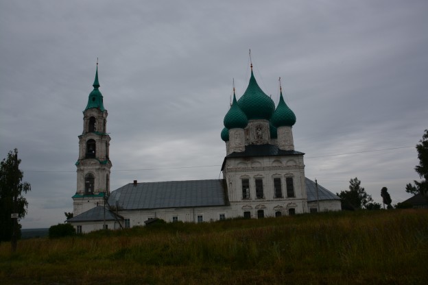
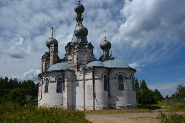
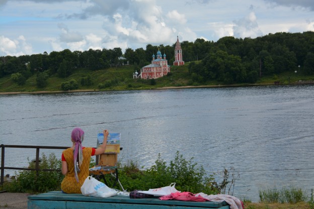
Stopped in the town of Tutayev and visited the exquisitely beautiful Church of the Resurrection. Tutayev is a single town located on both sides of the Volga but without a bridge. To get to the other side of the town, you either need a boat or travel 40km to Yaroslavl or Rybinsk. There were several interesting cathedrals and towers on the opposite bank from me but figuring out how to flag a private ferry with the bicycle seemed too complicated. I admired them from across the river and spent my time in the church I could reach.

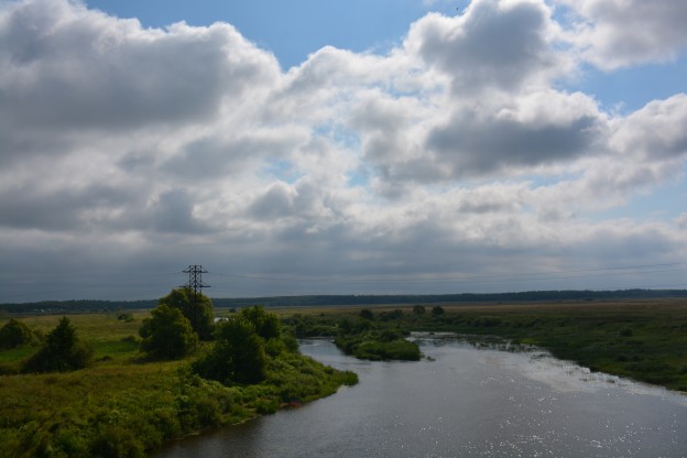
Simple ride into Rybinsk — a town probably most famous for being at the confluence of the Volga at ancient times and, thanks to Stalin, on the shores of the Rybinsk “Sea”. The Sea was formed in 1941 by the creation of a huge hydroelectric dam. At the time, it was the largest man-made body of water in the world. Today, the power output of the dam is minimal and the ecological damage debated, not to mention the 150,000 displaced people and nearly 633 villages which lie under the water. I’ll be getting an up close view as I travel up the eastern shoreline the next two days to Cherepovets.

20130722_0920_DSC_5690-reduced30

Day 51: Kostroma, Russia to Yaroslavl, Russia


View Larger Map

Start: Kostroma, Russia
End: Yaroslavl, Russia
Distance: 83.1km
Elevation Gain: 1134ft
Elevation Loss: 1118ft
Time: 4h45m
Reading Material:A World at Arms: A Global History of World War II – Gerhard L. Weinberg
Audio Material: Marketplace; Diaen Rehm News Roundups; World in Words; On The Media

Description
A nearly perfect bike touring day.

Light drizzle kept temps perfect. Road surface was highway but only 2-lane, light utilization and a decent shoulder. Good workout but arrived at destination Yaroslavl with enough time (and energy) to have a beer and check out some sights before turning in for the night.

Passed a large military facility that I will guess was for paratroopers based on the logo on the barbed wire gates. I didn’t stick around too long to confirm — would rather not meet any Spetsnaz. Found another fading brick church. This one was huge, empty and boarded up. But, it sported a super nice belltower.

Depending on how you count, Yaroslavl is the oldest of the Golden Ring cities. Located at the intersection of the Kotorosl and Volga Rivers, it has always been an important trading and transportation city. Just as the historical American city of Springfield was founded by its namesake Jebediah Springfield when he killed a bear with his bare hands, Yaroslavl the Wise founded the city and legend has it conquered a nearby clan by impressing them with his ability to wrestle a bear (hence the bear on the city’s Coat of Arms). The city was a favorite target for destruction by the Mongol Horde who repeatedly burned the primarily wooden town. Today, Yaroslavl retains importance with a population of 600,000 and multiple universities.

20130720_1316_DSC_5528-reduced30

Day 50: Lunevo, Russia to Kostroma, Russia


View Larger Map

Start: Lunevo, Russia
End: Kostroma, Russia
Distance: 36.7km
Elevation Gain: 582ft
Elevation Loss: 603ft
Time: 2h04m
Reading Material:A World at Arms: A Global History of World War II – Gerhard L. Weinberg
Audio Material: Marketplace; Bullseye (Rick Moranis interview)

Description
Quick trip on to the next Golden Ring stop just up the Volga: Kostroma.

On the A113, met a bike tourer headed in the opposite direction. Anatoyli had a nice, light setup with rear saddlebags. If we understood each other correctly, I believe he lives in Kostroma and was headed out for a nice little loop of Golden Ring towns.

Some excellent downhill traffic dodging into town. I played leapfrog with a wedding party and then passed them as they were disembarking by the river for a ceremony. Saw what I think was meant to be a sexy billboard advertising joining a convent (also, a reality TV program last night about a group of young women living in a convent)?

Rode around Kostroma’s ancient city center and famous trading stalls. Tomorrow, I’ll explore the city’s Romanov history.

20130718_1209_DSC_5452-reduced30

Day 49: Ivanovo, Russia to Lunevo, Russia


View Larger Map

Start: Ivanovo, Russia
End: Lunevo, Russia
Distance: 80.5km
Elevation Gain: 1115ft
Elevation Loss: 1161ft
Time: 5h07m
Reading Material:A World at Arms: A Global History of World War II – Gerhard L. Weinberg
Audio Material: World in Words (global Yiddish; bribery episode); This American Life (500th episode, maybe a bit too self-congratulatory); Stuff You Should Know; WTF (Jonah Hill episode)

Description
Finally met the Volga!

Passed several abandoned factories and crumbling Soviet concrete structures on the way out of Ivanovo. Still nice, cool temps as I continued to follow the A113 north. Spotted a roadside stand selling leftover stuffed animals from carnival games? Left the A113 and followed a small, choppy road past a giant power plant towards the Volga for 15km. Beautiful glimpses of the river. Along the way, discovered an abandoned brick church turning back to its original red color.

I’m staying in a cabin resort nestled in the deep and old forest along the banks of the Volga. After the ride, I walked through a Soviet-style family camp (absurd-looking exercise equipment; a group accordion sing-a-long) and took a dip in the river.

20130717_0809_DSC_5403-reduced30

Day 48: Suzdal, Russia to Ivanovo, Russia


View Larger Map

Start: Suzdal, Russia
End: Ivanovo, Russia
Distance: 84.5km
Elevation Gain: 1273ft
Elevation Loss: 1239ft
Time: 5h31m
Reading Material:Leningrad: The Epic Siege of World War II, 1941-1944 – Anna Reid
Audio Material: Marketplace; On The Media; Wait Wait Don’t Tell Me; Nerdist (Tig Notaro interview)

Description
Left the picturesque golden domes of Suzdal for the gritty textile city of Ivanovo. The merciful dark clouds and resulting cooler temps (hovering around a pleasant 75F) made for easy (if not overly exciting) riding on the motorway.

At several locations, passed men on the side of the rood selling assortments of industrial-sized samovars, gramophones and fake landscapes. I presume geared to the Muscovites on family holiday through the Golden Ring looking for a slice of pastoral Russia?

Ivanovo was the center of Russia’s textile industry and its history is closely intertwined with early worker strikes, revolts and possibly the first example of a local soviet before the Bolshevik revolution. The city seems on hard times since the last textile factories closed in 2000, however it has multiple universities and is trying to rebrand itself as a “City of Youth” — even qualifying as a contestant for the title of European Capital of Youth 2015. From my vantage point, however, I just saw lots of cars and a city grid where nearly every sub road was unpaved and potholed.

Tomorrow, I get back to the pastoral and meet up with the Volga.